
Reverse Geocoding
Reverse geocoding converts geographic coordinates (latitude/longitude) into human-readable addresses.
When to Use
Use reverse geocoding when you have:
- GPS coordinates from mobile devices
- Location data from IoT sensors
- Coordinates from mapping applications
- Lat/long values that need address labels
How to Use
Step 1: Prepare Your File
Your file should have columns for latitude and longitude:
id,latitude,longitude
1,40.7128,-74.0060
2,34.0522,-118.2437
3,41.8781,-87.6298
Step 2: Select Reverse Geocoding Mode
After uploading, toggle the geocoding mode to Reverse Geocoding.
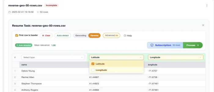
Step 3: Map Coordinate Columns
Select which columns contain:
- Latitude - Values typically between -90 and 90
- Longitude - Values typically between -180 and 180
Step 4: Process
Click Process and wait for results.
Results
Your output will include:
| Field | Description |
|---|---|
| Street Number | Building number |
| Street | Street name |
| City | City name |
| State | State/province |
| Zip | Postal code |
| Country | Country name |
| Formatted Address | Complete formatted address |
| Relevance | Accuracy score (0–1) — see Accuracy & Scoring for the distance bands (rooftop ≤30m, building ≤200m, street ≤500m, postcode ≤1500m, city beyond) |
Coordinate Formats
CSV2GEO accepts coordinates in decimal degrees format:
Valid Formats
40.7128(decimal degrees) ✓-74.0060(negative for West/South) ✓
Not Supported
40° 42' 46"(degrees/minutes/seconds) ✗N 40.7128, W 74.0060(cardinal directions) ✗
Convert DMS to decimal degrees before uploading.
API: widening the search radius
By default, reverse geocoding only returns results within 100 m of your pin. Rural coordinates (farmland, parks, remote roads) often fail because the nearest indexed address is further away.
If you're calling the API directly, pass ?radius= (in metres, max 1500) to widen the search:
GET /v1/reverse?lat=46.49125&lng=-120.395&radius=1000&api_key=geo_live_...The accuracy_score automatically decays with distance — a 577 m hit returns as accuracy: postcode, accuracy_score: 0.5 so you can filter or label client-side. Full bands documented at Accuracy & Scoring.
Next Steps
- Accuracy & Scoring - How relevance is computed
- Interactive Maps - Visualize your data
- Download Results - Export options